|
Cycling Through a Farming Landscape
Around Boyds and Germantown, Maryland
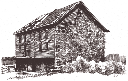
Many kinds of farming, past and present in Montgomery County, are illustrated by this bicycle trail through the area around Boyds. Dense forests, thin soils underlain by hardpan and bedrock, and isolation long condemned this land to rural poverty, heralded by the simple log cabins of early settlers. Many called it “the Desert of Maryland.” Subsistence farming was supplemented by small crops of tobacco, cured in log smoke houses far different from the flue-cured seed of southern Maryland and the plantation prosperity of the 18th century. As farming became more progressive and transportation improved by mid-19th century, the Boyds area entered the corn-and-wheat cycle which for 100 years the prevailing form of agriculture in these parts. This was the heyday of the single family farm. The new agricultural landscape was marked by the large bank barn, a type imported from Pennsylvania and suited to feeding livestock. Often these barns were decorated with ornamental iron ventilators. Hay and grain were loaded into the upper story to be housed and fed where the hay and grain were thrown down.
The coming of the railroad to Boyds in 1873 delivered cheaper fertilizers and provided access to the Washington and Baltimore markets. The modest production of butter and cream on general farms induced many farmers to specialize in dairying, and by 1910 refrigeration, milking machines and modern transportation had produced an impressive prosperity often traced in white painted clapboard farmhouses. Although dairy farms became specialized, they still grew feed for their cattle; particularly pasture, dried forage, and silage. Most still produced their own dairy replacement stock. Special milking “parlors” were built and later, buildings to contain the refrigerated milk awaiting pick-ups by stainless steel, refrigerated trailer trucks. Immediate and continuous refrigeration and high levels of sanitation made it possible to keep milk fresh for days and even weeks, but also made it possible to ship milk to the Washington market from Pennsylvania, upper New York State, and even from the Middle West. About 1955, the natural monopoly of the local dairy farmers was broken; milk prices fell, and more farmers turned to beef cattle and agricultural specialties, or sold their farms. Near Boyds, Germantown, a planned city, grew from a rural population of 2000 in 1980 to a city of close to 100,000 by 2009.
Since the original Old Farm Trail was laid out in the early 1980s, the farms have changed use or disappeared as development has occurred in the area, and as the economics of farming has changed. The farms identified on the tour are still standing although they are not owned by the farmer, but leased from the U.S. Department of Natural Resources, current owner .
Where to Park
Park at the MARC "station" in Boyds, on the South side of the tracks, behind the General Store.
 1. Boyds 1. Boyds
This extensive hiker/biker trail begins at the MARC station in Boyds. You may wish to divide the trail into different segments, some biked, some hiked and some by motor vehicle. Along the trail, you will see exquisite beauty, historical farms, nature at her finest and a trash heap among other sights. Please respect private property. “No Trespassing” means it is okay to stop and appreciate the history and beauty but it’s not okay to set one foot on the private side of the sign.
2. The Trail Begins
You will exit from the MARC parking lot onto a small piece of Clopper Road. Turn right, and you will be on the beginning of White Ground Road and the start of our trail. This is also a segment of MNCPPC’s Hoyles Mill Trail, beginning at Black Hills Park to the North. Our trail is bordered by abundant wild flowers and has small wooden bridges over little streamlets. The land in this area is underlain by hard diabase rock and was once owned by a rock mining company that planned to open a quarry. You will glimpse traces of the 20th century and come upon the ruins of a rather extensive entertainment park and ballfield used by African Americans until recent times. After about 1/2 mile on White Ground Road, as you pass the signage for Hoyle's Mill Conservation Park, turn left onto Hoyle’s Mill Road. In 1/2 mile, you will come to a gate barring motor vehicles, after which the road is gravel.
3. Little Seneca Creek Bridge
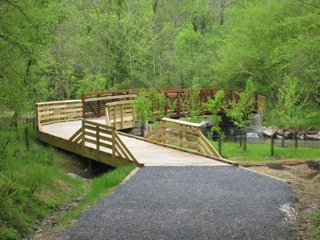 This bridge was built by MNCPPC in 2008 as part of the Hoyle’s Mill Hiker/Biker Trail, and is the location of the former ford on the creek that was used until the 1980s. Take some time here to gaze at the sparkling, clean water, the native trees and the recent plantings. Swiftly flowing water was once the electrical generator of today. This bridge was built by MNCPPC in 2008 as part of the Hoyle’s Mill Hiker/Biker Trail, and is the location of the former ford on the creek that was used until the 1980s. Take some time here to gaze at the sparkling, clean water, the native trees and the recent plantings. Swiftly flowing water was once the electrical generator of today. 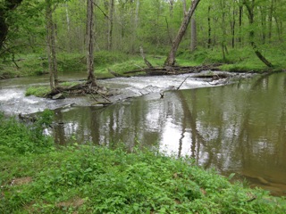 Mills, the important industry of the time, were built on every good stream; on the Seneca and its tributaries there were several. Mills transformed corn into cornmeal and wheat into flour. Local farmers brought wagonloads of grain to the mill, fording the Little Seneca at this point. Note the legend on the Germantown side of the bridge. Mills, the important industry of the time, were built on every good stream; on the Seneca and its tributaries there were several. Mills transformed corn into cornmeal and wheat into flour. Local farmers brought wagonloads of grain to the mill, fording the Little Seneca at this point. Note the legend on the Germantown side of the bridge.
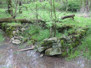
4. Hoyle’s Mill Ruins
 If you want to take this side trip, park your bike at the bridge and hike along the creek about half a mile upstream on the left hand side. The ruins are very easy to miss. Look closely for the mill race and follow it to the mill ruins. With your back to the stream, you may see rock chimneys, indicating the ruins of the Hoyle house. Close to the water you may locate the grinding stone, partially sunk into the ground. There are additional foundations. Take pictures but DO NOT REMOVE ANYTHING. If you want to take this side trip, park your bike at the bridge and hike along the creek about half a mile upstream on the left hand side. The ruins are very easy to miss. Look closely for the mill race and follow it to the mill ruins. With your back to the stream, you may see rock chimneys, indicating the ruins of the Hoyle house. Close to the water you may locate the grinding stone, partially sunk into the ground. There are additional foundations. Take pictures but DO NOT REMOVE ANYTHING.
 Back at the bridge, continue on the road to the second gate (East entrance to the Conservation Park). Here you will view the edges of Germantown: You have traveled from the 18th to the 21st century. At the ridge of the hill in front of you are two mature trees, bare in winter. On the left was the Ungelbe farm and on the right, the Westfall farm, both now gone. The Herbert King farm was closer to Clopper Road where the fire station and Methodist church now stand. King built the first Germantown subdivision and his name is repeated throughout this section of the city. King’s daughter, Jean, is the co-author of this guide. Back at the bridge, continue on the road to the second gate (East entrance to the Conservation Park). Here you will view the edges of Germantown: You have traveled from the 18th to the 21st century. At the ridge of the hill in front of you are two mature trees, bare in winter. On the left was the Ungelbe farm and on the right, the Westfall farm, both now gone. The Herbert King farm was closer to Clopper Road where the fire station and Methodist church now stand. King built the first Germantown subdivision and his name is repeated throughout this section of the city. King’s daughter, Jean, is the co-author of this guide.
5. Soccerplex
From Hoyle’s Mill Road, work your way through the subdivision to the Soccerplex. Turn left onto Bubbling Spring, right on Crestmont, right on King’s Crossing, right on Cornflower, left on Greene, right on Richter Farm Road. (Part of Herbert King’s farm was purchased from the Richter estate.) Turn right on Schaeffer Rd. to the Soccerplex. This was the farm of Jim and Macie King from 1912 until it was purchased by Montgomery County. It is now an extensive soccer and aquatics center with the old barn as its centerpiece.
A great fire destroyed fourteen of the farm buildings and those in use today were built in 1926. Large scale corn and wheat crops yielded grain locally milled to produce feed for dairy herds, and in some years as much as twenty-six train carloads of grain were shipped to market. However, the main product of the King farm was milk. At that time, when refrigeration was primitive, milk was kept cold in an ice house filled with blocks cut from a farm pond since drained. Each morning the milk was taken in 5-gallon cans by wagon to the Germantown station where it was shipped on the B&O Metropolitan Branch to Washington. The Kings were the first to use the rail line to ship their milk, but within a very few years more than 1100 gallons were shipped from Germantown every morning.
Explore a little and discover Jim and Macie King’s dairy barn, which is now being restored as The MOOseum, to be filled with artifacts of dairy farming.
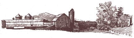
6. Schaeffer/Savage/Gray Rock Ranch
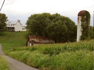
 Schaeffer Road continues south under the PEPCO power lines and then turns west, downhill past the southern edge of the King farm. This section of the farm is now used as an airpark for flying remotely controlled model airplanes – open to the public. Ascending a small hill, the second farm on the trail is seen across the fields to your left. The cluster of dairy barns and other farm buildings may be hidden by the corn in late summer; however, in spring they can easily be seen over the small green shoots of winter wheat. This farm was once a prosperous dairy farm owned by the Schaeffer, then Savage families. Today the property is owned by the DNR and leased to Gray Rock Ranch. Handsome farm buildings in good condition may be seen. The owners host western-style equestrian exhibitions such as “Mexican Rodeo.” Frequently there is a sign on the lane informing of these events. Visitors are welcome at that time. Schaeffer Road continues south under the PEPCO power lines and then turns west, downhill past the southern edge of the King farm. This section of the farm is now used as an airpark for flying remotely controlled model airplanes – open to the public. Ascending a small hill, the second farm on the trail is seen across the fields to your left. The cluster of dairy barns and other farm buildings may be hidden by the corn in late summer; however, in spring they can easily be seen over the small green shoots of winter wheat. This farm was once a prosperous dairy farm owned by the Schaeffer, then Savage families. Today the property is owned by the DNR and leased to Gray Rock Ranch. Handsome farm buildings in good condition may be seen. The owners host western-style equestrian exhibitions such as “Mexican Rodeo.” Frequently there is a sign on the lane informing of these events. Visitors are welcome at that time.
Look for a lane leading into the woods, on the left as you enter Gray Rock Ranch. You will come to a parking area that begins the Schaeffer Farm Trail, maintained by DNR. The DNR lands are used for controlled deer hunting, but also include extensive biker/hiker trails. Information on these can be found at http://www.dnr.state.md.us/publiclands/maps/schaefferfarmmap.html.
7. Americus Dawson Farm
 This historic farmhouse is restored by the tenant who leased the farm from DNR at a modest rate upon agreeing to the restoration. This historic farmhouse is restored by the tenant who leased the farm from DNR at a modest rate upon agreeing to the restoration.
8. Jones Dairy Ruins
Following Schaeffer Road downhill, on your right appears a cluster of barns and an abandoned farmhouse. These buildings were once the Jones farm but now they are used to store farm equipment and hay. Walk up to these barns for a close look. The concrete block construction of these barns and the concrete floor of the interior is typical of dairy buildings erected before 1920 to meet the Washington public health inspection standards.
The trail now continues through fields down to Little Seneca Creek. Many fishermen’s trails wind through the woods along the stream banks. Pedaling up the hill after crossing the Little Seneca, the cyclist may puff a little as the road climbs through abandoned fields and then enters cool woods at the junction with White Grounds Road. Turn right here and follow White Grounds Road as it first climbs high above Bucklodge Branch and then winds back down to the low, wet areas along the stream. In the summer, it is cool and shady here. You can take a short rest by the many tall trees along the stream.
 9. Gott Plantation Ruins 9. Gott Plantation Ruins
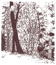
Benjamin Gott owned a large tobacco plantation where slaves tended the crops. After emancipation, Gott gave land on White Ground Road to his workers who built homes still, in some cases, maintained by their descendants. Gott was a founding family, marrying into the other first families of Germantown including the Bowmans who married Kings. The great sandstone chimney of the Gott house is still standing on ground carpeted with vinca, a gentle reminder of a gracious past. Look for the ruins on a hill before the powerlines.
Continue on White Grounds Road, through the historic African American community with their Currier and Ives church and school. “Boyd Negro School” is owned and maintained by the Boyds Historical Society. Peek in the windows for a scene from the early 1900s. Across from the school is Taylor Elementary School. Named for Edward Ulysses Taylor, superintendent of African American education, this was one of the last two schools in the county built during segregation. Taylor School survived a short time after integration, but is now used as a storage facility.
Bike through the Victorian village of Boyds to the MARC station and your car. You have seen over 200 years of farming history in Montgomery County. From the water-powered mill, you arrived in a new, planned, big city. You passed a playground of gaily colored plastic toys and a vast, natural area of native trees and clear streams, paved with crunchy leaves in the fall. You traveled from the historic White Grounds to King’s Crossing Boulevard.
Side Trip to the Castle
Back in your vehicle, you may wish to see Boyds’ mansion and Germantown’s castle.
 Continue straight ahead; White Grounds Road becomes Clopper. Look closely to your left across the tracks toward Seneca Lake and you may glimpse the Victorian mansion built by Mary Totten, the heiress to the Elias Howe sewing machine fortune. Howe invented the bobbin or winder. Mrs. Totten named the house Winderbourne. Continue straight ahead; White Grounds Road becomes Clopper. Look closely to your left across the tracks toward Seneca Lake and you may glimpse the Victorian mansion built by Mary Totten, the heiress to the Elias Howe sewing machine fortune. Howe invented the bobbin or winder. Mrs. Totten named the house Winderbourne.
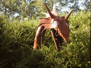
Continue on Clopper, turn right on Richter Farm Road, right on Kings Crossing Blvd, right on Autumn Gold, left on Crossview to the castle on your left, “Red Wall.” Look for the windmill. The carriage house behind the castle has a second floor for black tie dances. At the entrance to the property you will see a clump of mature evergreens. This is where the dragon lives. He peers through the upper branches. A former owner liked to show visitors her lovely grounds and when she came near these trees, she clicked a device in her hand and the dragon snorted smoke and flames. This is private property; observe from the road only.
To see the old hand drawn Trail Guide site maps for The Old Farm Trail (now out of date), please go here.
F. Gutheim, S. Miner 1978
B. Miller, K. Kyde 1997
Peg Coleman 2010 |